flowchart LR
  Q1["What does a sign oblige?"]:::q --> A1["Québec regulation<br/>+ sign posters"]:::src --> R1["meaning: settled<br/>placement: open"]:::res
  Q2["How does PlanX<br/>measure a radius?"]:::q --> A2["compare<br/>segment counts"]:::src --> R2["along the streets"]:::res
  Q3["Which way does a<br/>Mapillary sign face?"]:::q --> A3["test on stop signs<br/>we already know"]:::src --> R3["the way it faces,<br/>with noise"]:::res

  classDef q fill:none,stroke:#e6e6e6,color:#e6e6e6
  classDef src fill:none,stroke:#8a8a8a,color:#a6a6a6
  classDef res fill:none,stroke:#fe83cc,color:#fe83cc
Checking the sources
A question for each source
Some parts of Situ lean on sources I did not make. Before trusting one, I ask it a plain question and answer with a test I can run again.
Signs: what they mean
The Québec standard for road signs, Tome V, Signalisation routière, is sold and was out of my reach, so I used free sources. The Règlement sur la signalisation routière on LégisQuébec, current to 1 June 2026, gives the legal meaning of each kind of sign. The ministry’s 2026 posters (Québec.ca) and its online catalogue, the Répertoire des dispositifs, give their names and pictures.
| Article | Sign | Meaning |
|---|---|---|
| 3 | every prescription sign | it applies where it is installed |
| 7 | stop (P-10) | stop |
| 10 | no entry (P-40) | you may not enter this road |
| 13 | one way (P-80-1) | use the road in the direction shown |
| 18 | P-110-1 to P-110-4 | at this intersection, turn or go on as the arrow shows |
| 20 | P-110-6 to P-110-8 | at this intersection, do not turn or go on as the arrow shows |
The code numbers differ between sources: the regulation numbers the turn bans P-110-6 to P-110-8, while the 2026 poster shows P-110-62 for “no left turn”. So S3 reads a sign’s written meaning and ignores its code.
None of these sources says where a sign stands, before or after the junction. The only text on placement I found is a 2001 provincial guide quoting Tome V: turn signs stand “à proximité de l’endroit où la manœuvre doit être effectuée”, near where the turn is made (BAnQ). That does not say which corner, so placement has to be read from photos, one junction at a time.
PlanX: how far is a radius?
PlanX is the QGIS tool that gives each street segment its space syntax values, such as choice (roughly how often a street lies on the way between other places) and integration (roughly how easy it is to reach), each measured within a radius (what these are). Its manual (version 4.18, September 2026) calls the radius “metric radii in map units”, without saying whether 800 m runs along the streets or in a straight line, two very different neighbourhoods.
PlanX reports how many other segments each one found within the radius. For twelve Griffintown segments I counted again in two ways: the segments I can walk to within the radius, and those whose middle lies inside a circle of that radius. At 800 m, PlanX’s counts came to 0.89 of the walking counts and 0.57 of the circle counts; at 400 m, 0.92 and 0.53.
So the radius is measured along the streets (certain), and S2 reads it that way. PlanX’s counts sit a little under mine, most likely because it measures metres along the path with the fewest turns, which is a bit longer than the shortest (likely). I could not reproduce the counts exactly, so that detail stays open.
The manual also says the network has no direction, so the vehicle values describe the street layout without its one-way rules. I checked its normalised forms of choice and integration (NACH and NAIN, which can be compared between networks of different sizes) against the published papers in Reading closely. NACH matches Hillier, Yang and Turner (2012, p. 191) exactly, and PlanX counts each pair of segments once, the same definition as Turner (2007, p. 544) (how I found out). For NAIN the paper gives two other forms, which put the streets in the same order; the numbers compare only within one form.
Mapillary: which way does a sign face?
Mapillary reads its street photos with a machine and maps every sign it sees, with a compass angle. If that angle is the way the sign faces, it can settle which street a sign controls.
Getting the signs
I asked Mapillary for every feature it has mapped around the S1 network, in squares of about 400 m because it refuses large ones, and kept the traffic signs unchanged, with their dates. On 10 October that gave 1,455 signs, 838 of them regulatory, among them 235 stop detections and 88 no-entry signs.
Testing the direction on signs we already know
A stop sign faces the drivers it stops, and S3 already knows, for every city stop post, which street those drivers arrive along. So the right answer is known in advance. For each city stop post I took the nearest Mapillary stop sign within 15 m and compared.
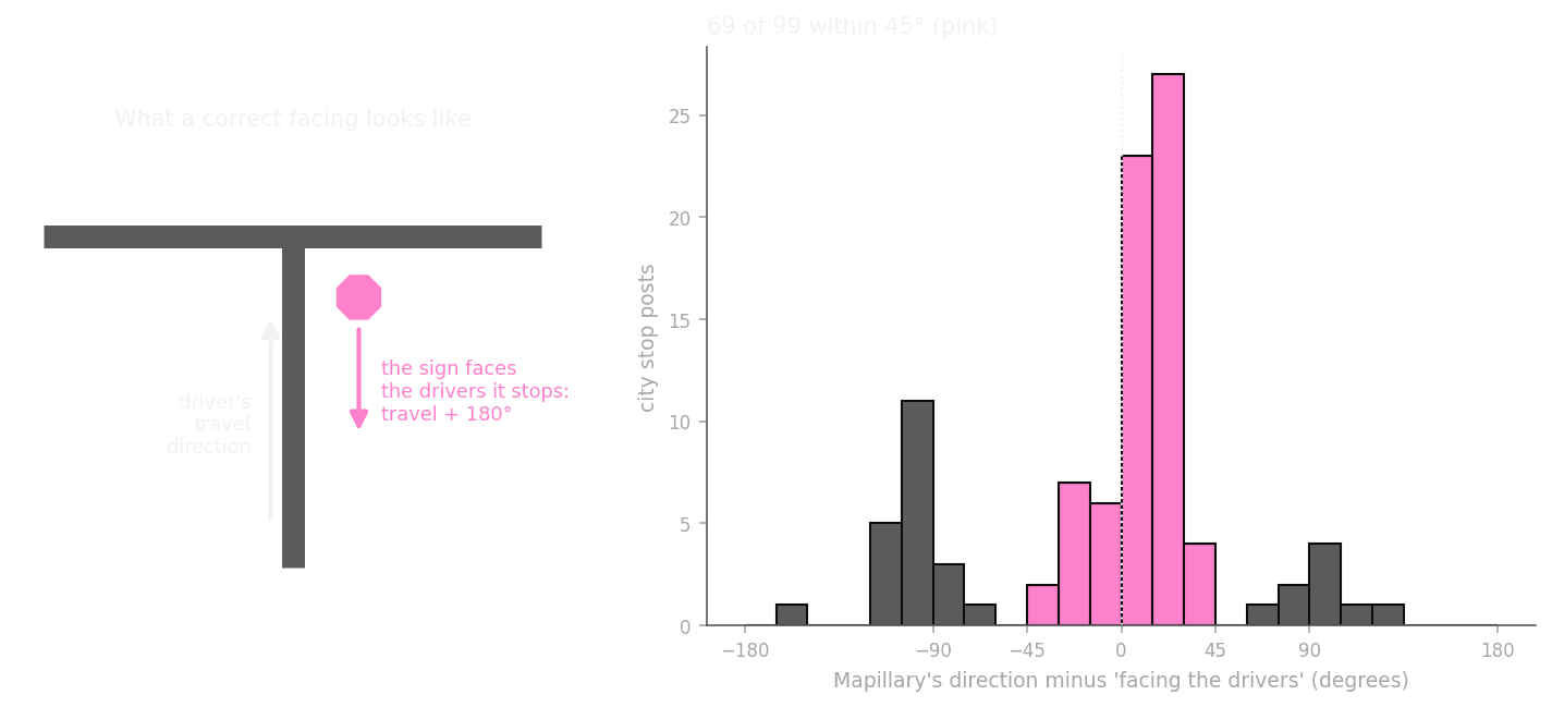
Of 139 city stop posts, 99 had a Mapillary stop sign within 15 m. For 69 of those, the angle was within 45° of facing the drivers, and only one pointed the way they travel. The median difference was 21°.
So the angle is the way the sign faces (likely). A smaller group sits near 90° off, with a simple cause (likely): at an all-way stop, four stop signs stand within a few metres, and the nearest one can face the cross street. The main peak sits about 15° off zero, and I do not know why yet. Fifteen degrees never confuses two streets meeting at a junction, so it does not change how I use the angle. Still, a machine reading is evidence to check. Where a sign’s placement was in doubt, S3 uses Mapillary’s facing and then the photo itself (S3 checks with photos).